 |
Alpinism Home |
|
Mt Baker (10,781ft / 3277m)Easton GlacierAugust 27-28, 2009 |
All photos courtesy of the Mark Phillip Chapman Collection.
My oldest brother Mark and I had been talking about climbing Mt Rainier last year but the early arrival of his grandson, Caiyan, rightly trumped those plans so this year we set our sites on Mt Baker, picked a date that was free on our crowded calendars and as luck would have it, the climb went and went well!
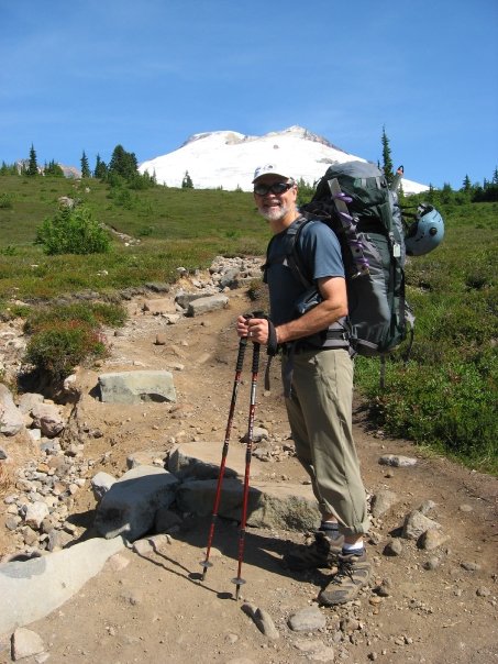
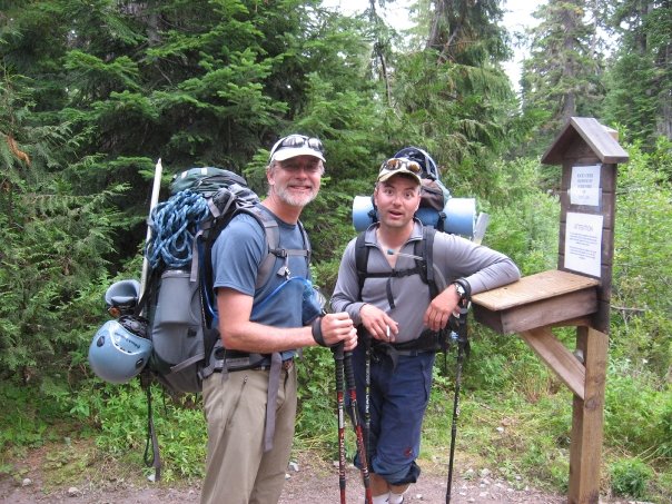
Since the road to the Coleman-Deming route trailhead is washed out we decided on the Easton Glacier route. Mark and his wife Penny live on Samish Island, just outside of Mt Vernon so Mt Baker is in their backyard, so to speak. I arrived at his house at 7am and we loaded up the Honda and made the relatively short drive to the trailhead. Mark has been the director of Camp Chimacum, a Jr High boys camp, and each year they make an overnight camping trip to Blue Lake. We were surprised that our trail head was just off the same forest road from the Blue Lake. The Shreibers Meadow trail head parking area was quite large with lots of parking, two restrooms, and picnic tables.
We knew that the elevation gain was 7100' so we were a little worried when the trail meandered through meadows and streams without gaining much elevation. After a mile or so we reached the forest and were soon making our way up a ridge via steep switchbacks. Even on a Thursday morning we met young families and several other hikers on the trail. After a few miles we came to a junction that we hadn't planned on. We pulled out the USGS maps but the trail wasn't on it. Fortunately a young family hiked up behind us and showed us the correct trail on their Green Trails map. We needed to continue towards Park Butte then branch off on the trail that leads up to the Railroad Grade. I told Mark that the summit was worth a lot more than my pride so I had no problem asking for directions!
The Railroad Grade follows the ridge of the west moraine of the Easton Glacier. Here the mountain was right in front of us and the snout of the Easton Glacier could be seen below us. On the ridge we met two climbers, a younger man and an older man, who were hiking out. We asked them how their climb went and learned that they had trouble route finding on the glacier and turned around. This wasn't the news we were hoping for, but we took the information with a grain of salt. Oftentimes the real reasons for turning around go unsaid. We wished them a good hike out and continued on our way. Further up the Railroad Grade we spotted a group descending near Sherman Peak, below and south east of the summit. This made us feel better since they had most likely made the summit so the snow bridges must be intact!
We stopped near the top of the ridge for a bite to eat then descended a little to a large sandy camping spot where several climbers were talking and lounging around. We had seen an Alpine Ascents Int'l guiding company van in the parking lot, so we assumed that these folks were part of that group. They had summitted the day before and said the snow bridges were thin in places but passable but the headwall leading to the summit was pretty icy. More useful news!
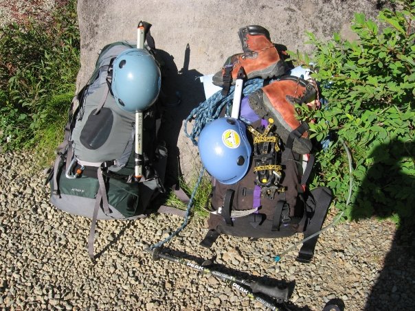
I like to camp as high as possible so we continued up the trail from the camp and stopped near a stream to fill up our water bladders. A few hundred feet above this point we came to the first snowfield in a basin with a large crumbly cave to our right. There were many boulders strewn about the snow where they had fallen from the cave so we carefully made our way past. We made the decision to wear light hikers and tennis shoes on the hike in and carried our mountaineering boots on our packs. This was a great idea as the added comfort to our feet more than made up for the added weight to our packs.
|
|
|
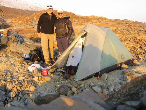
We followed a faint boot track a little further up a short but steep snow slope and could see the edge of the glacier. This was a perfect place to camp! We explored the area and found a sandy, level spot to pitch the tent. Knowing that this was where we would be starting from early the next morning we decided to rope up and go explore the glacier to get a better idea of our route that we would be climbing in the dark. We followed some frozen mud below the glacier then made our way up to some saturated glacier ice with several pools of water and streams flowing out. With the extremely hot summer we had I could see how the glacier was melting rapidly. I felt much better once we were above this saturated ice. I had visions of an ice dam breaking below us and getting washed away!
Soon we were amongst large crevasses on more level terrain and I felt a little more comfortable. We picked our way through the maze of cracks and soon found ourselves on large plateau with an obvious boot path continuing up. It was around 4 o'clock in the afternoon/evening and the sunlight was beautiful on the glacier. We both wished we had brought our cameras with us. Having scoped out the beginning of our route for the next morning and getting our "crampon legs" underneath us we felt much better about the next day and climbed back down to our camp.
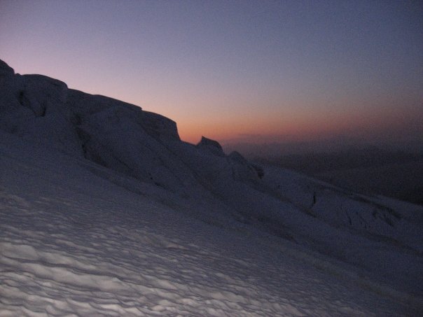
Once the tent was up back at our campsite, I brewed up some water in my JetBoil stove for our dinners. We both got Rice and Chicken! It has the most calories per the weight. I shouldn't have had the Emmentaler swiss cheese as an appetizer since I had to finish my dinner in two sittings. It was a lot of food, but I knew I would need the calories the next day. I had fogotten my spoon so I had to share with Mark's. He jokingly asked me if this was some weight saving scheme. We washed the rest of our dinner down with some Herbal Peach tea with Nido and sugar! After dinner Mark took his camera and explored the area and got some great pictures of nearby waterfalls on Portrait Rock and some beautiful sunset pictures.
We laid out our gear for the next morning, re-filled our water bottles for breakfast, and crawled into the tent. We played a game of Pass-the-Pigs which Mark won handily. I had forgot to bring my iPod speaker so we had to share earbuds as we listened to Jimmy Buffett's Volcano! It was a very warm evening and I had no problem staying warm in my 45F REI Sub Kilo Flash sleeping bag, although I would have preferred it to be much colder for the sake of the stability of the glacier and snowbridges.
|
|
|
|
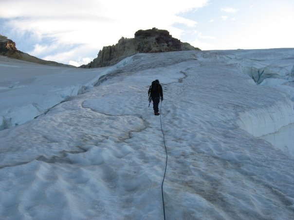
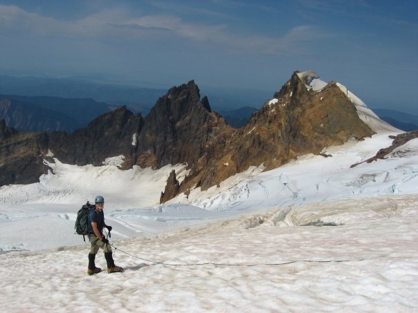
Two o'clock came early as we climbed out of the tent under a star strewn sky! I boiled up water for our oatmeal and hot cocoa. I was surprised how hungry I was after being so stuffed the evening before. We secured our camp then loaded up our packs then walked to the snow where we had left our crampons. We tied back into the rope with our kiwi coils which were still in place and started up the glacier. It was 3:45am. There was a warm breeze blowing off the glacier.
The best laid plans of mice and men...I tried to re-trace our route from the day before, but I believe we were too far east as nothing looked familiar and I couldn't find the wand we had placed the day before. The new route we took eventually brought us to the same plateau we reached earlier so it all worked out and might have actually been a little more direct!
I don't think I'll ever get used to climbing by headlamp on glaciers in the wee hours of the morning. From the plateau we followed some melted out boot tracks heading west and found ourselves at the base of a steep jumble of broken up glacier. We found a narrow finger of ice that we could climb up and luckily got to another level plateau. We were definitely west of where we wanted to be and I tried to find a boot track that would follow the path of least resistance up the glacier. In the dark I told Mark, "Just because we can climb water ice, doesn't mean we need to!"
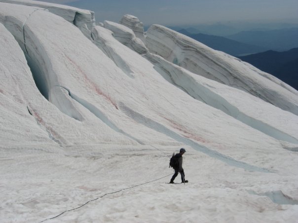
Unfortunately the boot tracks I thought I had been following ended at the base of a second broken section of ice and once again we had to weave our way up through the mess. I was glad I had brought two ice screws in addtion to the three snow pickets we carried as we used them all to make a running belay. At one point I headed up a snow finger between two large crevasses only to down climb and then climb up the left side. This proved to be a good choice as the two crevasses rejoined above the finger to make a dead end. We followed a corridor between two even larger crevasses which brought us to happier ground. "We chose...wisely", I quoted to Mark as we regained the boot track! The day before when we were doing our reconnaissance Mark asked what the names of the various parts of the glacier were. I told him what I knew then said I mostly break down the parts into either "happy" parts and "not-so" happy parts. We had just come through some "not-so" happy parts and were now back to a "happy" part.
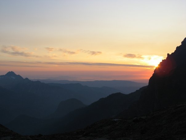
As luck would have it, about the time we regained the boot pack the sky began to get light in the east and my spirits rose considerably. At a large crevasse free part of the glacier we came upon three tents and a Mega-mid. At first I thought they were rocks. We figured that these must be the climbers we saw descending from the day before. Talk about camping high on the mountain! We continued climbing up the glacier working together to make end runs around the numerous crevasses. Mark had been reading up on two person glacier travel in Freedom of the Hills and did an awesome job of keeping the slack out the rope while not tugging. Earlier we had talked about the logistics of two person climbing teams and how important it is to avoid crevass falls since setting up a pulley system for extraction, solo is unlikely. An ounce of prevention is worth a pound of cure!
Mark lead up the middle part of the glacier and soon we were below the sub peak of Sherman Peak. We climbed past a subtle right turn in the route and soon recognized our mistake seeing a large basin with the route climbing up the right hand side. Since I had been second on the rope, I was in the lead again as we backtracked a few feet to where we the route climbed up an icy slab. There were snow dicey snow bridges to the left so I continued climbing up to the base of the bergshrund below Sherman Peak. Here we thought we had come to a dead end when we saw that we could follow a narrow ridge to a point where we could make a small jump down to some scree which lead to a "happier" part of the glacier. It went and soon we were climbing back on yellowish sulfur stained snow on the boot track.
At the summit crater, we walked in coils and followed a side path that traversed to the edge where we could look down and see the steam rising. It was an awesome sight! The heat of the vent was melting the surrounding snow and we could hear the hissing of the melted water as it turned into steam. The strong stench of sulfur made me recall Boromir's line during the Council of Elrond scene in The Fellowship of the Ring and I said, "The very air you breath is a poison gas! Not with 10,000 men could you do this. It is folly!" This other-worldly environment certainly felt like Mordor.
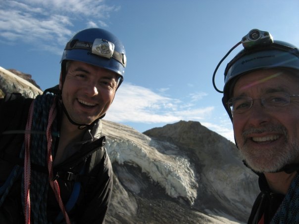
I am without a small digital camera since my Nikon CoolPix finally met its end while climbing in Leavenworth earlier this summer, so I had my Olympus film camera with me with only three pictures left on the roll. So the lion's share of recording our climb was left to Mark. We took some pictures at the crater since we were both so impressed with this amazing view. Once back on the glacier we could see that we were getting very close to the summit headwall!
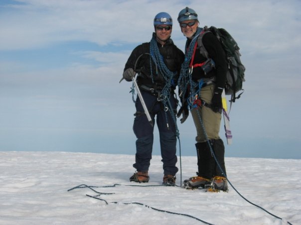
A few delicate snow bridge crossings later we were at the bergshrund below the summit headwall. Once again we found ourselves on icy mud just like what we had started out on earlier that morning. I found a spot in some good ice where I could place a screw to protect the exposed traverse above the bergschrund. Once above this section there was a narrow but decent boot track that lead up to the summit plateau. It was 9:45am when we reached the summit. I had a few climbs earlier this summer that ended without a summit, so I was very pleased to have this go!
I had heard from other friends who had climbed Mt Baker that the summit plateau was huge without an obvious summit. The map shows that Grant Peak, a remote, small, point on the eastern edge of the summit,is the true high point although my altimeter and Mark's GPS read 10,700. This worked for us! On the exposed summit the wind had picked up considerably so we put on our extra layers, ate some of my summit Toblerone chocolate and took a ton of pictures. It was one of the more spectacular summit views I've seen. Mt Challenger and the jagged Picket range to the northeast, the Olympics to the southwest, Glacier Peak, to the south east, and what I believed to be Whitehorse and Three Fingers to the south! We took a timed summit shot with Mark's tripod velcroed to the shaft of his ice axe. We stayed on the summit for about 45 minutes then started our way down.
|
|
|
|
We took our time going down as the weather was perfect. We met a young woman and a large man climbing up just as we descended the headwall. We commented how nice the weather was and how it was actaully too nice with it being so warm. We wished them luck and continued down. From time to time the rope would tug slightly as Mark had slowed to take a picture. The crevasses were truly incredible in this late August climbing season.
Back at camp we were glad to be off the glacier having safely negotiated many tricky snow bridge crossings. We were also glad to take our boots off and put our light hiking shoes back on! What a difference this made. We re-filled our water bottles from the stream near our camp before heading back down. We met many backpackers and a few climbers heading in as we descended. Near the railroad grade we saw about 20 marmots scattered across the fields. A few of them whistled back to me. The long hike out was made more bareable by the infinite number of blueberries and huckleberries lining the trail!
Eventually we arrived at the trailhead and had some other hikers take one last picture of us, our Mt Baker adventure finally coming to a close. Thank you Mark for a most memorable climb! Well done!